
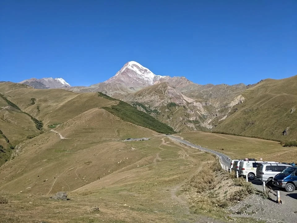
Kazbegi National Park protects one of Georgia’s most dramatic high-mountain landscapes.
North of Tbilisi, the landscape rises abruptly into the Greater Caucasus, where deep river gorges cut between dark volcanic cliffs, glaciers spill from 5,000 m peaks and isolated villages sit beneath slopes that remain snow-streaked well into summer.
The main base is Stepantsminda, still commonly called Kazbegi. Most travellers know the town for the classic view of Gergeti Trinity Church beneath Mount Kazbek, but the surrounding valleys offer far more than a single viewpoint.
Around it are the mineral springs and abandoned settlements of Truso, the sheer-sided Dariali Gorge, waterfalls at Gveleti, the alpine village of Juta and the jagged Chaukhi massif. Higher still are glaciers, mountaineering routes and habitats for some of the Caucasus’s most distinctive wildlife.
Kazbegi is one of Georgia’s easiest mountain regions to reach, yet within an hour of leaving the highway it can feel thoroughly wild.
Its combination of easy access and genuine high-mountain terrain makes Kazbegi one of Georgia’s most rewarding regions for a short mountain stay.
Kazbegi National Park at a glance
| Detail | Information |
|---|---|
| Region | Mtskheta-Mtianeti |
| Main base | Stepantsminda |
| Landscape | High Caucasus mountains, alpine meadows, forests, glaciers and gorges |
| Lowest elevation | About 1,400 m |
| Area listed by Georgia’s environment ministry | 78,543.4 hectares |
| Forest cover | About 35% |
| Best for | Hiking, scenery, wildlife, photography and mountain culture |
| Best general season | June to October |
| Winter visits | Possible, but weather and road conditions are less predictable |
| From Tbilisi | Roughly 3 hours by road in normal conditions |
| Main road | Georgian Military Highway |
| Major peak | Mount Kazbek / Mkinvartsveri, 5,054 m |
| Difficulty | Anything from short walks to serious mountaineering |
| Recommended stay | 2–4 nights |
One important update is worth making to older descriptions of the park. Georgia’s environment ministry gives Kazbegi National Park an area of 78,543.4 hectares, far larger than the figure of roughly 8,700 hectares still repeated in older tourism material. Official tourism information states that about 35% is forest; much of the remaining landscape consists of alpine meadows, moraines, snowy peaks and cliffs.
Why visit Kazbegi National Park?
Kazbegi is often treated as a quick excursion from Tbilisi: drive north, photograph Gergeti Trinity Church, have lunch and return to the capital.
That is possible, but it leaves little time for the valleys and trails that make the region distinctive.
The real appeal of Kazbegi is its variety. One morning can be spent walking through an almost treeless volcanic valley stained orange by mineral water; the next beneath the sharp granite towers of Chaukhi. There are easy waterfall walks, full-day hikes, birdwatching routes and glacier approaches, often within a relatively small geographical area.
And unlike several of Georgia’s more remote mountain regions, Stepantsminda is reachable by a major road from Tbilisi. Georgia’s tourism authority puts the normal driving time at just under three hours.
This accessibility makes it possible to experience high-altitude scenery without spending an additional day reaching the trailheads.
A park spread across the mountains
Visitors expecting a conventional national park with an entrance gate, ticket office and a network of neatly interconnected trails may be surprised.
Kazbegi is better thought of as a large protected mountain landscape spread across different valleys and ecosystems.
There is no single place where everyone “enters Kazbegi National Park.” Instead, Stepantsminda works as the practical hub, with roads and trails branching toward Gergeti, Sno and Juta, Dariali, Gveleti and other mountain areas.
Georgia’s official tourism site highlights Dariali Valley, Gveleti Waterfalls, Khada Valley, Sno and Juta, the Chaukhi massif and Mount Kazbek among the principal landscapes associated with Kazbegi National Park.
This scattered geography is one of the park’s strengths. It also means you should plan Kazbegi by valley and activity, rather than trying to “see the national park” in a single stop.
The landscape and geology of Kazbegi
Kazbegi occupies the northern slopes of the Greater Caucasus in the basin of the Tergi River, also widely known outside Georgia as the Terek.
This is not a gentle mountain landscape.
The relief is steep, deeply eroded and geologically complex. Volcanic formations, lava layers and exposed rock are particularly visible around Dariali, where the Tergi has cut a narrow passage through the mountains.
Above the valleys are moraines and glacial terrain. Above those are permanent snowfields and some of the highest summits in Georgia.
The dominant summit is Mount Kazbek, or Mkinvartsveri, which reaches 5,054 m. Georgia Travel describes it as an extinct volcano, with several glaciers—including Devdoraki and Ortsveri—descending from its slopes.
From central Stepantsminda, Kazbek can appear deceptively close. Its scale becomes clearer once you begin walking towards Gergeti and the glacier approach.
Stepantsminda: the gateway to Kazbegi
Stepantsminda is the logical base for exploring the national park.
The town lies in the Tergi valley only around 11km from Georgia’s northern border. Hotels, family guesthouses, restaurants, supermarkets, taxis and mountain guides are all concentrated here.
You’ll still hear people call the town Kazbegi, its Soviet-era name. Both names are widely understood, so don’t be surprised to see “Kazbegi” on accommodation listings and “Stepantsminda” on maps.
For most first-time visitors, staying here makes far more sense than moving accommodation every night.
From Stepantsminda you can make day trips in almost every direction.
Best places to visit in and around Kazbegi National Park
Gergeti Trinity Church
Gergeti Trinity Church is the region’s best-known cultural landmark.
Standing at roughly 2,170 m above Stepantsminda, the 14th-century church has become one of the defining images of Georgia: a solitary stone building against the snowy mass of Kazbek.
It is worth visiting even if you’ve seen the photograph hundreds of times.
A paved road reaches the church, so you can go by taxi or private vehicle. The uphill walk from Stepantsminda generally takes around 1.5–2 hours, depending on your starting point, route and pace.
From the plateau, views extend across Stepantsminda, the Tergi valley and surrounding ridges.
Try to arrive early.
By late morning Gergeti can become one of the busiest places in the region, whereas sunrise and early morning often retain the sense of isolation that made it famous in the first place.
Gergeti Glacier
Gergeti is also the starting point for a much more demanding mountain journey.
Trails continue above the church toward Altihut, at around 3,014 m, and farther toward the Gergeti Glacier and the traditional approach to Mount Kazbek.
This is no longer casual sightseeing.
The higher you go, the more seriously you need to consider altitude, weather, route finding and mountain conditions. Georgia’s tourism authority classifies the glacier-area outing as a strenuous full-day experience requiring good physical condition and appropriate equipment.
Do not walk onto a glacier simply because other people appear to be doing so. Crevasses may be difficult to see, and glacier travel requires specific knowledge and equipment.
For most hikers, reaching a high viewpoint without stepping onto glacial ice provides more than enough drama.
Gveleti Waterfalls
For something considerably easier, head north into Dariali Gorge.
Near the small settlement of Gveleti, short trails lead to two waterfalls, usually referred to as the Small and Large Gveleti Waterfalls.
The drive from Stepantsminda is only around 7km. From the road, the route continues on foot through a narrow mountain landscape of shrubs, streams and cliffs. The Agency of Protected Areas describes the final approach as approximately 700 m, while Georgia Travel notes about 750 m between the two falls.
The larger waterfall drops around 30 m.
This is a particularly good choice if you have limited time or want an easy nature walk after a longer hike the previous day.
Wear shoes with good grip because the rocks near the waterfalls can be wet and slippery.
Dariali Gorge
Continue north and the mountains close around the road.
Dariali Gorge is one of the most dramatic sections of the Georgian Military Highway, squeezed between steep rock faces as the Tergi River races toward the Russian border.
For centuries, this was one of the crucial passages across the Caucasus.
The Agency of Protected Areas describes the gorge as stretching roughly 11km from the Stepantsminda area toward Upper Larsi. Historic routes, defensive remains, waterfalls and extraordinary exposed geology can all be found along the corridor.
The modern road makes the passage easier to cross, but the narrow corridor and towering cliffs still reveal its historic strategic importance. Use designated pull-offs and remain well clear of traffic.
Truso Valley
Truso Valley is among the best day trips in the entire Kazbegi region.
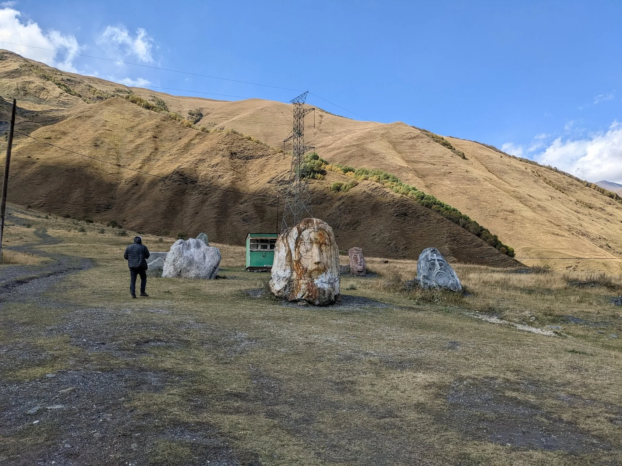
West of the Georgian Military Highway near Kobi, it is broader and gentler than Dariali: a high valley of grassland, ruined towers, abandoned settlements, mineral springs and mountains streaked with snow.
The mineral activity is what makes Truso particularly unusual.
Water emerging from underground deposits minerals across the valley floor, producing white, orange and reddish travertine formations. Around Abano, mineral water also creates vividly coloured pools and wetlands.
A relatively easy hike takes you through the valley toward the Zakagori fortress complex.
There is one geographical detail worth understanding. Truso now has its own protected designation: the Agency of Protected Areas lists the Truso Protected Landscape as a 7,007-hectare protected area within Kazbegi Municipality. In other words, travellers commonly group Truso with a “Kazbegi National Park” itinerary, but its current protected-area status is more specific.
Border rules in Truso
Truso runs toward the Russian border, and travellers should pay attention to signs and instructions from Georgian border authorities.
Georgia Travel advises carrying identification if planning to proceed beyond the Zakagori area, where additional permission may be required.
Do not wander past checkpoints or restricted signs simply because your map shows a trail continuing.
And don’t walk on the delicate travertine. These mineral formations grow slowly and are easily damaged.
Juta and the Chaukhi Mountains
If Gergeti is Kazbegi’s famous view, Juta is its great hiking gateway.
The village sits at around 2,200 m at the end of the Sno Valley, beneath the serrated Chaukhi massif. In summer, the grassy valley and dark, jagged peaks look almost theatrical.
A relatively easy trail runs from Juta towards the base of Chaukhi and passes near a small lake. Distance and walking time depend on the chosen turnaround point, so allow at least several hours if you want to explore beyond the first viewpoints.
Stronger hikers can continue much farther.
One classic route climbs over Chaukhi Pass toward the coloured Abudelauri Lakes and Roshka in neighboring Khevsureti. This is a proper mountain trek rather than a casual extension of the Juta walk. The route involves steep ground and a river crossing, and conditions are best in summer.
For an easy day, walk from Juta toward Chaukhi, find a good viewpoint, have lunch and return.
For a relaxed day, there is no need to continue to the high pass.
Sno Valley
The road to Juta first passes through Sno, one of the more accessible villages near Stepantsminda.
The landscape becomes progressively narrower and more rural as you move up the valley. Sno itself is known for its defensive tower, while several small villages and side valleys preserve the architectural character of historical Khevi.
It makes a good cultural stop on the way to Juta, particularly if mountain cloud has made serious hiking unattractive.
Khada and other quieter valleys
Not every corner of Kazbegi receives the traffic of Gergeti or Juta.
The broader protected landscape includes less-visited valleys where the experience is primarily about walking beneath high ridges rather than ticking off one famous sight.
Georgia Travel specifically highlights Khada Valley, while the Agency of Protected Areas also points travellers toward areas such as Artkhmo and Khda.
These areas are better suited to travellers with extra time, reliable maps and a preference for quieter routes.
For a first Kazbegi trip of two or three days, however, Gergeti, Truso, Juta and Dariali offer more than enough.
Best hikes in Kazbegi
Kazbegi works unusually well because the hiking ranges from short walks to mountaineering objectives. Compare additional routes in our guides to hiking trails in Georgia’s Caucasus and trekking in Georgia.
| Route | Approximate level | Time to allow | Best for |
|---|---|---|---|
| Gveleti Waterfalls | Easy | 1–2 hours | Short nature walk |
| Stepantsminda–Gergeti Church | Easy–moderate | 2–3 hours return | Views and culture |
| Juta–Chaukhi foothills | Easy–moderate | 3–4 hours | Classic alpine scenery |
| Truso Valley | Easy–moderate | Half/full day | Mineral springs and ruins |
| Gergeti–Altihut | Moderate–hard | Most of a day | High-mountain views |
| Gergeti Glacier area | Hard | Full day | Experienced hikers |
| Juta–Chaukhi Pass–Abudelauri | Hard | Long day/overnight | Serious trekking |
| Mount Kazbek | Mountaineering | Multi-day | Experienced climbers with suitable skills |
Georgia’s official hiking guide lists Truso, Juta and the Gergeti Glacier among the principal trekking areas around Kazbegi.
Trail conditions, snow levels and river crossings change throughout the year, so treat published times as estimates rather than timetables.
Climbing Mount Kazbek
Although Kazbek is visible from Stepantsminda, its summit route is a serious mountaineering objective rather than an ordinary hike.
The normal route involves high altitude, glaciers, crevasses, snow, ice and potentially dangerous rockfall. Georgia Travel recommends that climbers without substantial mountaineering experience use a professional guide. The classic route generally includes acclimatization and several days on the mountain.
The summit stands at 5,054 m.
At that altitude, acclimatization matters independently of how fit you are at sea level.
If your goal is simply to experience the mountain rather than stand on top of it, hiking above Gergeti toward Altihut provides spectacular views without turning your holiday into an alpine expedition.
Flora: much more than empty mountains
From a distance, Kazbegi can seem almost bare.
Look more closely and the biodiversity is extraordinary.
The Agency of Protected Areas records 1,347 plant species, approximately 26% of them endemic, within the park’s botanical zone. Alpine, subalpine and xerophytic plant communities occupy different elevations and exposures.
Forests cling mainly to steep slopes and sheltered valleys.
Characteristic species include:
- Litvinov’s birch
- Sosnovsky’s pine
- Junipers
- Caucasian rhododendron
- Sea buckthorn
- Oriental beech
- High-mountain oak
The sea-buckthorn groves around Stepantsminda are particularly notable, while rhododendron can cover substantial areas of higher slopes.
Late spring and early summer are the most rewarding periods for flowers.
By autumn, the attraction shifts toward golden grassland, berries and changing foliage.
Wildlife in Kazbegi National Park
Large mammals survive here partly because so much of the terrain is difficult for humans to reach.
The park supports East Caucasian tur, chamois and brown bear, along with smaller mammals such as martens and wild cats.
That does not mean bears stroll down Stepantsminda’s main street every evening.
Most large wildlife keeps its distance from populated areas, and sightings usually require patience, binoculars and some luck.
The cliffs above the valleys are particularly important habitat for mountain ungulates. Scan high rocky slopes early in the morning and you have a better chance of seeing tur than if you spend your day looking at the road.
One of Georgia’s best birdwatching areas
Kazbegi is especially rewarding for birders.
The park’s cliffs and deep valleys support golden eagles, griffon vultures and bearded vultures, while two Caucasus specialties—the Caucasian black grouse and Caucasian snowcock—draw dedicated birdwatchers to the region.
Spring is particularly interesting.
Georgia Travel notes that birdwatchers commonly search the slopes around Stepantsminda and Mount Kuro for grouse and snowcock, as well as rosefinches and other high-altitude species.
Bring binoculars.
The snowcock’s camouflage makes binoculars particularly useful.
The Mokheves and the culture of Khevi
Kazbegi is not empty wilderness. People have lived in these valleys for centuries.
The historical region is known as Khevi, and its inhabitants are traditionally called Mokheves—literally people of the gorge.
The geography shaped local life.
Communities occupied an important northern gateway into Georgia and developed traditions adapted to a combination of pastoral life, mountain isolation and the need to defend key routes across the Caucasus.
Christianity became deeply rooted here, but older mountain customs survived alongside formal Orthodox practice. Religious feasts, family traditions and local beliefs sometimes reveal a cultural mixture familiar elsewhere in Georgia’s highlands.
Fortified towers, village churches and shrines are therefore not decorative additions to the landscape. They are part of the landscape’s history.
Historic places around Kazbegi
Gergeti Trinity Church is the obvious highlight, but it is not the only historic monument.
Travellers exploring the valleys can also encounter:
- Medieval churches around Sioni and Garbani
- Defensive towers and remains in Sno
- Abandoned and semi-abandoned settlements in Truso
- Zakagori Fortress in Truso Valley
- Historic defensive remains in Dariali Gorge
- Small shrines and religious sites scattered through Khevi
Allowing time for these places changes the character of a Kazbegi trip.
Without them, the region can look like spectacular scenery. With them, it becomes a lived-in mountain landscape with several centuries of visible history.
Best time to visit Kazbegi National Park
There is no single perfect month; the best season depends on what you intend to do. For a broader seasonal comparison, see our guide to when to travel to Georgia.
April and May
Spring arrives slowly at altitude.
Stepantsminda may be green while high trails remain buried under snow. Waterfalls are powerful, wildflowers begin appearing lower down and snowy mountains make a beautiful backdrop.
For serious hiking, however, May can still be early.
Expect mud, snow patches and variable conditions.
June
June is one of the best all-round months.
Valleys are green, flowers are abundant and most lower hiking routes become accessible. High passes may still hold snow, especially early in the month.
It is also generally quieter than July and August.
July and August
These are the main hiking months.
High routes are at their most accessible, Juta is fully active and long daylight makes ambitious day hikes easier.
The downside is popularity.
Gergeti, Stepantsminda and the most famous trails can become busy, particularly on weekends.
Start walking early and the crowds rapidly thin.
September
September may be the best compromise.
Weather can remain excellent, the main summer crowds ease and mountain visibility is often good. Nights become noticeably colder as the month progresses.
For experienced hikers, early and mid-September are particularly appealing.
October
Autumn colors arrive lower down while the first significant snow may appear on higher trails.
October can be beautiful, but plans need more flexibility.
A sunny 18°C afternoon and a snowy pass can exist on the same day.
November to March
Winter completely changes Kazbegi.
Snow turns Gergeti and the surrounding mountains into the landscape seen on countless postcards, while Stepantsminda becomes much quieter.
But many hiking areas are not realistically accessible as ordinary walking routes.
Snow, avalanche conditions and winter road closures must be taken seriously. Specialist ski touring exists around Gergeti, but Georgia Travel specifically recommends appropriate avalanche equipment and professional guidance for such routes.
How to get to Kazbegi National Park
From Tbilisi
Most visitors travel to Stepantsminda via the Georgian Military Highway. The route can also be experienced on a Kazbegi tour from Tbilisi.
The route passes:
Tbilisi → Zhinvali → Ananuri → Gudauri → Jvari Pass → Kobi → Stepantsminda
Under normal conditions, the drive is roughly three hours without lengthy stops.
In reality, first-time travellers often take longer because the road itself is part of the trip.
Ananuri Fortress, Zhinvali Reservoir, Gudauri and several high-mountain viewpoints all invite stops.
Marshrutka
Minibuses operate between Tbilisi and Stepantsminda and remain one of the cheapest ways to reach Kazbegi.
They are practical rather than scenic-tour vehicles: don’t expect the driver to stop every time a particularly handsome mountain appears outside the window.
Shared or private taxi
A taxi costs more but gives you flexibility.
For two or more travellers, arranging a driver can make sense if you want to stop at Ananuri, Gudauri and viewpoints along the way.
Agree on the route and price in advance.
Rental car
Driving yourself gives maximum independence once in Kazbegi.
In good summer weather, the main highway is straightforward for experienced drivers, although traffic, trucks and rapidly changing mountain conditions require attention.
Side roads are different.
Routes toward villages such as Juta or deep into mountain valleys may involve gravel or rough surfaces, so check both road conditions and the restrictions in your rental agreement.
Winter road conditions
The high section around Gudauri and Jvari Pass is vulnerable to snow, ice and avalanche-control closures.
If traveling in winter, check current road conditions on the day rather than assuming yesterday’s information still applies.
Closures and traffic controls can make the journey considerably longer.
Getting around Kazbegi
Stepantsminda itself is walkable.
For attractions farther away, you have several options:
- Hire a local taxi or 4WD
- Arrange a driver through your guesthouse
- Join a local excursion
- Rent a car
- Hike directly from town where practical
For Truso and Juta, transport to the trailhead saves substantial time.
For Gergeti, walking from town is part of the experience and is usually the better choice for active travellers.
How many days do you need in Kazbegi?
One day is possible. Two nights should be the minimum for most independent travellers. Three or four nights are better.
One day
Visit Gergeti Trinity Church and perhaps Gveleti or Dariali.
This provides only a brief introduction to the region.
Two days
Add either Truso or Juta.
This allows one full valley excursion in addition to Gergeti.
Three days
Visit Gergeti, hike Juta and explore Truso, with Dariali and Gveleti fitting naturally around them.
Four days or more
Add longer hikes, birdwatching, quieter valleys or a day above Gergeti toward Altihut.
Extra time also provides insurance against bad weather.
In Kazbegi, that matters.
Suggested three-day Kazbegi itinerary
Day 1: Georgian Military Highway and Gergeti
Travel from Tbilisi, stopping at Ananuri and Gudauri.
Check into your accommodation in Stepantsminda, then walk or drive to Gergeti Trinity Church in the afternoon.
If Kazbek is visible, resist the urge to leave immediately after taking the obvious photograph. Walk around the plateau and watch the light change.
Day 2: Juta and Chaukhi
Drive through Sno Valley to Juta.
Walk toward the Chaukhi massif and spend several hours in the valley. Strong hikers can continue farther; casual walkers can turn around whenever the view seems unlikely to improve much—which happens quite early.
Return to Stepantsminda for dinner.
Day 3: Truso or Dariali
Choose Truso for a longer, gentler walking day among mineral springs and historic ruins.
Choose Dariali and Gveleti if you prefer shorter walks and dramatic gorge scenery.
Return to Tbilisi in the late afternoon or stay another night and avoid spending half the day watching the highway after dark.
What to pack
Even in summer, Kazbegi requires mountain clothing rather than city assumptions.
Bring:
- Hiking or walking shoes with good grip
- Waterproof jacket
- Warm mid-layer
- Sun hat
- Sunscreen
- Refillable water bottle
- Sunglasses
- Small first-aid kit
- Offline map
- Power bank
- Passport or ID for border-adjacent valleys
- Trekking poles for longer routes if you use them
- Binoculars if you’re interested in wildlife
A sunny morning in Stepantsminda does not guarantee similar conditions later in the day at 3,000 m.
Layers are more useful than one very heavy jacket.
Mountain safety
Kazbegi is approachable, but it remains high mountain terrain.
The most useful rules are straightforward.
Check the forecast
Weather changes rapidly in the Greater Caucasus.
A route that is easy in sunshine can become uncomfortable—or dangerous—in fog, thunderstorms or fresh snow.
Start early
Afternoon clouds and storms are common in mountain environments, and an early departure gives you more daylight if the hike takes longer than expected.
Respect altitude
Stepantsminda already sits high, and trails climb rapidly from there.
Above 3,000 m, some visitors begin noticing headaches, unusual tiredness or shortness of breath. Don’t confuse determination with acclimatization.
Don’t improvise on glaciers
Mount Kazbek’s glacier routes require appropriate expertise.
The presence of a visible footpath does not make glacier travel safe.
Carry offline navigation
Mobile coverage is reasonably good around towns and roads but should never be your only navigation system in remote valleys.
Tell somebody where you’re going
For long or quiet routes, tell your guesthouse, guide or travel companion your planned destination and approximate return time.
Border areas
Both Dariali and Truso bring travellers close to Georgia’s international border.
Stay on established visitor routes, carry ID and obey Georgian police and border-guard instructions. Truso visitors intending to proceed past the Zakagori area should pay particular attention to current access rules.
Do not continue beyond signs or checkpoints without explicit permission.
Responsible travel in Kazbegi
Kazbegi’s popularity has increased rapidly, placing pressure on places that were never designed for large visitor numbers.
A few habits make a meaningful difference:
- Carry rubbish out. Remote valleys do not have urban waste infrastructure.
- Stay off fragile travertines. In Truso, walking over mineral formations damages them.
- Use established trails. Alpine vegetation grows slowly and recovers slowly.
- Do not approach wildlife. Binoculars exist for a reason.
- Support village businesses. Guesthouses, drivers and small cafés keep tourism income in mountain communities.
- Respect churches and shrines. Many are active religious places, even when they appear isolated.
- Leave gates as you find them. Hiking routes frequently cross grazing land.
- Give livestock and shepherd dogs space.
Kazbegi is a lived-in mountain region, but visitors can still reduce pressure on its fragile habitats and village infrastructure.
Is Kazbegi suitable for families?
Yes, provided the itinerary is sensible.
Gergeti by vehicle, Gveleti Waterfall, Dariali Gorge and shorter walks from Juta work well with children who enjoy being outdoors.
Long glacier hikes and high passes obviously belong in a different category.
Families should also remember that weather changes faster than small children generally appreciate. Carry spare warm clothing even on apparently perfect days.
Is Kazbegi National Park free to visit?
Kazbegi does not function like a fenced attraction with a single entrance gate and one general ticket. Our overview of the national parks of Georgia explains how the country’s different protected-area categories operate.
Most sightseeing involves public roads, villages and hiking routes spread through the region. Transport, guides, accommodation and particular visitor services may of course have their own charges.
For current regulations or activities in protected zones, check with the Kazbegi National Park Administration in Stepantsminda. The Agency of Protected Areas maintains a local administration and publishes visitor contacts on its official site.
Where to stay
For a first visit, Stepantsminda is the obvious base.
It offers everything from family guesthouses to stylish mountain hotels, along with the widest choice of restaurants and transport.
Stay in Gergeti village if you prefer a quieter setting close to the church trail.
Consider Juta for one night if hiking and mountain silence are priorities. Spending the evening there after the day visitors leave provides an entirely different experience from rushing in and out by vehicle.
In summer, book ahead for weekends.
Kazbegi or Svaneti?
Travellers often ask which Georgian mountain region they should choose.
The answer depends on time.
Choose Kazbegi if you want:
- Easy access from Tbilisi
- Spectacular scenery with limited travel time
- Good day hikes
- A two- or three-night mountain trip
- Gergeti Trinity Church and Mount Kazbek
Choose Svaneti if you want:
- A longer mountain journey
- Multi-day trekking
- Medieval tower villages
- A stronger sense of geographical isolation
With enough time, visit both.
They look and feel surprisingly different.
Is Kazbegi National Park worth visiting?
Yes, particularly for travellers who want high-mountain scenery within a few hours of Tbilisi.
Kazbegi succeeds because it doesn’t force travellers into one type of trip.
You can spend the morning photographing a medieval church, the afternoon hiking beside a waterfall and the following day walking toward a wall of 3,500 m peaks. Birdwatchers can search for Caucasian endemics; mountaineers can prepare for Kazbek; people with no interest in strenuous hiking can simply drive through some of Georgia’s finest scenery.
The region is more rewarding when you allow time beyond a single sightseeing stop.
Stay overnight.
Walk beyond the car parks, stop in Sno and give Truso or Juta a full day. An early start also provides quieter trails and more flexibility if the weather changes.
The scale of the Caucasus is difficult to appreciate through a windscreen, and even a short walk adds considerably to the experience.
Frequently Asked Questions About Kazbegi National Park
Where is Kazbegi National Park?
Kazbegi National Park is in Mtskheta-Mtianeti in northern Georgia, on the northern slopes of the Greater Caucasus around Stepantsminda and the Tergi River basin. Its lowest areas begin at roughly 1,400 metres above sea level.
How large is Kazbegi National Park?
Georgia’s environment ministry gives the park’s area as 78,543.4 hectares. Much smaller figures found in older travel material reflect earlier boundaries or protected-area arrangements.
How far is Kazbegi from Tbilisi?
Stepantsminda is approximately a three-hour drive from Tbilisi in normal conditions. Sightseeing stops, traffic, snow or temporary road restrictions can make the journey longer.
What is the best time to visit Kazbegi?
June through September is generally the most reliable period for ordinary hiking. June brings green valleys and flowers, July and August provide the best access to higher routes, and September usually has fewer visitors.
Can I visit Kazbegi in winter?
Yes. Stepantsminda and Gergeti remain popular in winter, but many hiking routes become snowbound and the Georgian Military Highway can face temporary restrictions. Backcountry winter activities require suitable equipment and experience.
Do I need a 4WD in Kazbegi?
A 4WD is not normally needed for Stepantsminda or the main highway in good conditions. A suitable higher-clearance vehicle may be useful on rougher side roads, and current road conditions should always be checked.
What are the easiest hikes in Kazbegi?
The Gveleti Waterfalls, the walk to Gergeti Trinity Church, the lower Juta Valley and sections of Truso Valley are among the most approachable options in suitable weather. Distances and surface conditions still need to be considered.
Can beginners climb Mount Kazbek?
Mount Kazbek is not a beginner hiking route. The summit climb involves glaciers, crevasses, snow, ice, high altitude and mountaineering skills; people without suitable experience should use a qualified guide.
What wildlife lives in Kazbegi National Park?
The park supports East Caucasian tur, chamois and brown bear. Its notable birds include golden eagle, griffon vulture, bearded vulture, Caucasian black grouse and Caucasian snowcock.
Is Truso Valley part of Kazbegi National Park?
Truso is commonly included in Kazbegi itineraries, but it also has its own designation. Truso Protected Landscape was established in 2021 and covers 7,007 hectares in Kazbegi Municipality.
How many nights should I spend in Kazbegi?
Two nights is a useful minimum. Three nights allows time for Gergeti and two major excursions, such as Juta and Truso, while providing some flexibility for changing mountain weather.
What should I not miss in Kazbegi?
First-time visitors should prioritise Gergeti Trinity Church, Juta and the Chaukhi massif, Truso Valley, Dariali Gorge and the Gveleti Waterfalls. Together they show the region’s cultural and landscape variety.
Plan a Kazbegi Tour from Tbilisi
A guided trip simplifies transport along the Georgian Military Highway and allows time for stops at Zhinvali Reservoir, Ananuri, Gudauri and Gergeti Trinity Church. Choose our one-day Kazbegi tour from Tbilisi for the main highlights or the two-day Kazbegi tour for a slower visit.
For hiking, photography or a route adapted to your group, explore our private tours in Georgia or contact Highlander Travel.



[…] Mkinvartsveri, a 5,054-metre dormant stratovolcano. Stepantsminda is also a convenient gateway to Kazbegi National Park and several of the region’s best-known […]
[…] Kazbegi […]
[…] everything else in the area, from Gergeti Trinity to the Truso valley, see our Kazbegi National Park guide and Gergeti Trinity Church […]