The Georgian Military Highway is one of the most rewarding road journeys in Georgia. Running north from Tbilisi towards Stepantsminda and the Russian border, it follows the Aragvi River into the Greater Caucasus before crossing the high mountains at Jvari Pass.
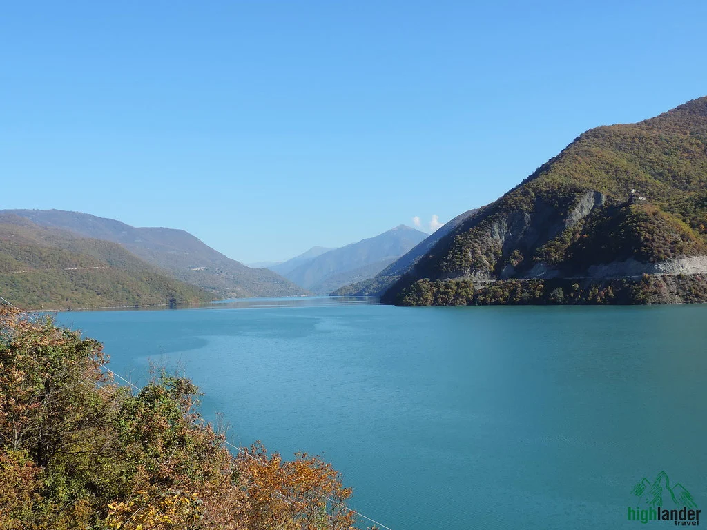
Along the way are medieval fortifications, the turquoise Zhinvali Reservoir, mountain villages, ski slopes, mineral springs and some of the country’s finest roadside views. The direct journey from Tbilisi to Stepantsminda is approximately 157 km and usually takes around three hours in normal conditions, but a sightseeing trip needs six to eight hours.
Georgian Military Highway at a glance
| Detail | Information |
|---|---|
| Main tourist section | Tbilisi to Stepantsminda |
| Distance | Approximately 157 km |
| Direct driving time | Around 3 hours in normal conditions |
| Recommended sightseeing time | 6–8 hours |
| Highest point | Jvari Pass, 2,379 m |
| Main road | S3 / E117 |
| Road surface | Paved |
| Best general season | May to October |
| Winter travel | Possible, but temporary restrictions and closures occur |
| Best overnight stop | Stepantsminda |
| Ideal trip length | Two days, if time allows |
Why is it called the Georgian Military Highway?
People have crossed this part of the Caucasus since antiquity, following river valleys and the Dariali Gorge between the South and North Caucasus. Traders, armies, diplomats and migrants used the passage long before a modern road existed.
The present name largely comes from the Russian imperial period. Military engineers began constructing the road in its modern form in 1799, and work continued through much of the 19th century as the Russian Empire sought a dependable route across the Caucasus.
The historic road continues north through Dariali Gorge to Vladikavkaz in Russia. Most visitors, however, use “Georgian Military Highway” for the scenic Georgian section between Tbilisi and Stepantsminda. It remains an important international transport route, so sightseeing vehicles share it with heavy freight traffic.
Planning the drive
| Stop | Approximate position from Tbilisi | Time to allow |
|---|---|---|
| Zhinvali Reservoir viewpoints | 50–60 km | 15–30 minutes |
| Ananuri Fortress | Approximately 60 km | 45–75 minutes |
| Pasanauri | Approximately 70 km | 45–90 minutes |
| Gudauri | Approximately 120 km | 20–45 minutes |
| Gudauri Panorama | Just beyond Gudauri | 20–40 minutes |
| Jvari Pass and travertines | Upper highway | 20–40 minutes |
| Stepantsminda | Approximately 157 km | Overnight recommended |
| Gergeti Trinity Church | Above Stepantsminda | 1–3 hours |
Zhinvali Reservoir
Zhinvali Reservoir is often the first major viewpoint on the journey. The road traces the artificial lake through wooded hills, and its water can appear grey-blue or vivid turquoise depending on the light and weather.
The reservoir was created for hydroelectric generation and water supply, but its mountain setting makes it a popular photography stop. Use an established pull-off and keep the vehicle completely clear of traffic lanes and bends.
Ananuri Fortress
Ananuri Fortress stands above Zhinvali Reservoir approximately 60 km from Tbilisi. The complex controlled an important section of the Aragvi Valley and served the local Aragvi dynasty. Its surviving buildings date broadly from the 14th to the 18th centuries.
Enter the defensive walls to see the churches, towers and carved exterior of the Church of the Mother of God. Where access is permitted, elevated sections provide memorable views over the reservoir. Allow 45–75 minutes for a useful visit rather than treating Ananuri as a quick photo stop.
Should you stop at Zhinvali and Ananuri separately?
Yes, although you do not need a long stop at both. Use one safe viewpoint for a broad panorama of Zhinvali Reservoir, then spend most of your time inside Ananuri Fortress, where history and lake views come together.
Pasanauri: stop for khinkali
Pasanauri is closely associated with khinkali, Georgia’s broth-filled dumplings, and makes a practical lunch stop. It is often advertised as the birthplace of khinkali, although the dish has broader roots across Georgia’s mountain regions.
Traditional meat khinkali contain hot broth. Hold the doughy top, bite carefully into the side and drink the liquid before eating the rest. Many restaurants also offer mushroom, potato or cheese fillings.
The White and Black Aragvi
Near Pasanauri, branches traditionally known as the White and Black Aragvi meet. Their appearance changes with weather, sediment and season, so the water does not always show the sharp two-colour division seen in promotional photographs. It is still an interesting short stop that illustrates how the river system shaped settlement and travel in the region.
The climb towards Gudauri
North of Pasanauri, the valley narrows and the road climbs towards the main Caucasus watershed. Bends become tighter, overtaking opportunities decrease and heavy trucks remain common. Drive patiently and use only safe, designated places to stop.
Mleta and the old mountain route
Around Mleta, the historic road begins its serious ascent towards Gudauri. Mleta is normally a pass-through point for first-time visitors. It is also associated with the demanding route to Lomisa Monastery, but that hike requires a separate day and suitable preparation.
Gudauri
Gudauri, at approximately 2,196 m, is Georgia’s best-known high-altitude ski resort. Winter brings skiing and snowboarding, while warmer months are used for hiking, mountain biking and paragliding.
For road travellers, Gudauri is useful for fuel, food, coffee and accommodation. It also provides a practical overnight alternative when winter conditions make the onward journey to Stepantsminda uncertain.
Gudauri Panorama
The vast circular structure beyond Gudauri is known as the Gudauri Panorama, Friendship Monument or Russia–Georgia Friendship Monument. Its colourful mosaics and projecting platform overlook a deep mountain valley.
The Soviet-era monument was completed in 1983 for the bicentenary of the Treaty of Georgievsk. It is one of the highway’s busiest stops, particularly from late morning, so an early visit generally provides more space.
Paragliding in Gudauri
Tandem paragliding operates around Gudauri in suitable weather. Choose an experienced, insured operator that supplies appropriate safety equipment and is willing to cancel when wind, cloud or visibility makes flying unsafe. Wear closed shoes and warm layers, even outside winter.
Jvari Pass
The Georgian Military Highway reaches its highest point at Jvari Pass, also called Cross Pass, at approximately 2,379 m above sea level. The open alpine terrain is exposed to rapidly changing weather, and temperatures can be much lower than in Tbilisi.
The Georgian word jvari means “cross”, referring to the cross that marked the mountain crossing. Stop only where parking and conditions allow. The pass marks the watershed: south of it, the road follows the Aragvi system; north of it, the route descends towards the Tergi basin.
Jvari Pass Travertine Natural Monument
White, cream and orange mineral deposits appear beside the road near the pass. The Jvari Pass Travertine Natural Monument forms as mineral-rich spring water deposits calcium carbonate on the hillside; iron compounds contribute to the orange colouring.
The formation lies at approximately 2,197 m, around 10 km from Gudauri. View it from the roadside and avoid walking or climbing on the actively forming, easily damaged surface.
Kobi and the route to Truso Valley
Descending from Jvari Pass brings you to Kobi, an important junction for the wider Kazbegi region. The turn towards Truso Valley begins nearby, leading to an alpine landscape of mineral springs, travertine, abandoned settlements and ruined defensive structures.
A proper Truso Valley hike does not fit comfortably into the same day as Ananuri, Gudauri and Gergeti. Stay in Stepantsminda and return the following morning. In winter, the Gudauri–Kobi road section is particularly vulnerable to restrictions caused by snow and avalanche risk.
Stepantsminda: arrival in Kazbegi
Stepantsminda, still widely called Kazbegi, sits at approximately 1,750 m in the Tergi River valley. Officially, Kazbegi is the municipality and Stepantsminda is the town, although travellers and local businesses often use the names interchangeably.
The town is a base for Gergeti Trinity Church, Gveleti waterfalls, Dariali Gorge, Sno, Juta, Truso Valley and numerous walking routes across Mtskheta-Mtianeti.
Stay overnight if you can
A return day trip from Tbilisi is possible, but one night in Stepantsminda gives you more time and a second opportunity to see Mount Kazbek. The mountain can remain hidden by cloud for hours before appearing at sunset or early the following morning.
Gergeti Trinity Church
Gergeti Trinity Church stands above Stepantsminda at approximately 2,170 m, with 5,054 m Mount Kazbek behind it on clear days. The 14th-century church remains an active Georgian Orthodox religious site.
A paved road now climbs from Stepantsminda towards the church, so a four-wheel-drive vehicle is not normally required in good conditions. Local taxis operate the route. If you walk, allow roughly 1.5–2 hours uphill depending on your starting point, route, fitness and weather, plus time at the church and for the descent.
Wear modest clothing, follow instructions at the entrance and remember that services or religious activity may affect access. Walk beyond the first car-park viewpoint for different perspectives over Stepantsminda and the surrounding mountains.
Beyond Stepantsminda: Dariali Gorge
North of Stepantsminda, the Tergi River enters Dariali Gorge, where cliffs close around the road as it approaches the Russian border. This narrow corridor has served for centuries as an important gateway through the Caucasus.
Gveleti waterfalls are nearby and can be added to a second day in Kazbegi. Unless you intend to cross the international border and have checked all current entry requirements, there is no reason for an ordinary sightseeing drive to continue to the checkpoint.
One day or two?
| Trip style | What works |
|---|---|
| Fast day trip | Ananuri, Gudauri Panorama, Jvari Pass, Stepantsminda and Gergeti |
| Relaxed day trip | Zhinvali, Ananuri, Pasanauri lunch, Gudauri Panorama, Jvari Pass and Gergeti |
| Two-day trip | Main highway stops, one night in Stepantsminda and one excursion to Juta, Truso, Gveleti or Dariali |
| Three-day trip | The full road journey, two substantial Kazbegi excursions and greater flexibility for the weather |
Best time to drive the Georgian Military Highway
Late spring: May and June
Valleys are green, rivers run strongly and high peaks often retain snow. May can still bring snow, poor visibility or restrictions around Jvari Pass, so check conditions before departure.
Summer: July and August
Summer generally provides the easiest access for sightseeing and hiking. Long days help with side trips to Juta and Truso, but Ananuri, Gudauri Panorama and Gergeti can be busy from late morning.
Autumn: September and October
September combines comfortable temperatures with good access and often-clear mountain views. By October, forests around Ananuri begin changing colour while fresh snow becomes possible at higher elevations. See our guide to the best time to travel to Georgia for wider seasonal advice.
Winter: November to April
Winter landscapes can be spectacular, and Gudauri operates as a ski resort. However, snow and avalanche danger can cause temporary closures or vehicle restrictions on the Gudauri–Kobi section. Check the official Roads Department information on the day you travel and keep plans flexible.
Important: Do not plan a winter airport connection or other time-critical journey on the assumption that the pass will remain open.
Driving the Georgian Military Highway yourself
You do not normally need a four-wheel-drive vehicle to travel from Tbilisi to Stepantsminda in good conditions because the main highway is paved. You do need confidence on mountain roads, patience around heavy trucks and a willingness to change plans when the weather deteriorates.
Road-trip essentials
- Start early: leaving Tbilisi in the morning gives you time for stops and reduces the risk of reaching Stepantsminda after dark.
- Check current road conditions: this is essential in winter and spring, especially for the Gudauri–Kobi section.
- Use proper pull-offs: never stop in a traffic lane, tunnel, blind bend or avalanche-prone area for photographs.
- Carry warm layers: Jvari Pass can be cold and windy even when Tbilisi is hot.
- Take water and snacks: restaurants are available, but traffic and weather can cause delays.
- Download an offline map: do not rely entirely on mobile reception.
- Allow extra time for trucks: the route is an international freight corridor.
- Use suitable winter equipment: tyres, chains or other requirements can vary with conditions and temporary restrictions.
Rental car, private driver, tour or marshrutka?
Rental car
A rental car gives you the most control over stops and timing. It is best suited to experienced drivers who are comfortable with mountain roads. Check the rental agreement before leaving paved roads for remote valley trailheads.
Private driver
A private driver provides flexibility without the stress of overtaking, parking or monitoring winter conditions. Confirm in advance that the price includes all the sightseeing stops you want rather than transport only.
Organised tour
A one-day Kazbegi tour from Tbilisi is convenient when time is limited and you want the logistics handled. A two-day Kazbegi tour allows a slower pace, an overnight stay and an additional valley or waterfall excursion.
Marshrutka
Minibuses between Tbilisi and Stepantsminda are inexpensive transport, but they are not designed for sightseeing. They generally do not stop at every fortress, viewpoint and natural attraction. Choose a tour, driver or rental car if the road journey itself is your priority.
Where to eat along the road
Pasanauri is the traditional lunch stop, particularly for khinkali. Gudauri has a good range of restaurants and cafés during the ski season, while Stepantsminda offers the widest choice for dinner. For a day trip, an early lunch in Pasanauri works well; on a two-day itinerary, consider a lighter road stop and a longer evening meal in Stepantsminda.
Best photography stops
Ananuri and Zhinvali are particularly attractive in morning light and autumn colour. Gudauri Panorama works well when cloud adds depth to the valley, while the open terrain around Jvari Pass suits wide compositions. Always park legally and remain clear of traffic.
For the classic view of Gergeti Trinity Church and Mount Kazbek, an overnight stay gives you the best chance to work around changing cloud and light. Cloudy weather is not necessarily a disadvantage: the mountain can appear suddenly and atmospheric conditions often create stronger photographs than a clear midday sky.
Should you add Mtskheta?
Mtskheta lies near the beginning of the route. Combining it with Kazbegi works well when you have at least two days. On a one-day return journey to Stepantsminda, visit Mtskheta separately so Svetitskhoveli Cathedral, Jvari Monastery and the old centre receive enough time.
What not to miss when time is limited
Prioritise Ananuri Fortress, Gudauri Panorama, Jvari Pass and Gergeti Trinity Church. Add lunch in Pasanauri if timing permits. Zhinvali Reservoir can be viewed during a short roadside stop, while Gudauri town itself can be skipped outside ski season if you are not eating or staying there.
Is the Georgian Military Highway dangerous?
In normal summer conditions, this is a major paved highway used by ordinary vehicles. The principal risks are changing mountain weather, heavy truck traffic, unsafe overtaking and winter avalanche conditions on the upper section.
Drive defensively, keep the driver focused on the road and use established parking places. In winter and spring, follow official restrictions rather than relying on an app’s estimated travel time.
Is the drive worthwhile when Kazbek is cloudy?
Yes. Mount Kazbek is the most famous sight at the northern end, but Zhinvali, Ananuri, Gudauri, Jvari Pass and the surrounding valleys remain worthwhile in cloudy weather. Conditions can also change quickly, which is another reason to stay overnight in Stepantsminda.
Suggested two-day Georgian Military Highway itinerary
Day 1: Tbilisi to Stepantsminda
Leave Tbilisi early, stop briefly at Zhinvali Reservoir and spend approximately an hour at Ananuri Fortress. Continue to Pasanauri for an early lunch, then climb towards Gudauri. Visit Gudauri Panorama, cross Jvari Pass and stop at the travertine before descending through Kobi.
Reach Stepantsminda during the afternoon. Visit Gergeti Trinity Church before sunset if the weather is clear, or try early the following morning if Mount Kazbek is hidden.
Day 2: Kazbegi and return
After Gergeti, choose one additional excursion. Dariali Gorge and Gveleti suit a relatively relaxed day. Truso Valley is better for travellers who want a longer walk, while Juta and the Chaukhi Mountains suit those prioritising alpine scenery. Check seasonal access and return towards Tbilisi with enough daylight for the drive.
Frequently asked questions
How long is the Georgian Military Highway?
The historic Georgian Military Road runs for approximately 212 km between Tbilisi and Vladikavkaz. Most visitors explore the roughly 157 km section from Tbilisi to Stepantsminda.
How long does it take to drive from Tbilisi to Kazbegi?
Allow around three hours without substantial stops in normal conditions. A sightseeing journey with Ananuri, Pasanauri, Gudauri and Jvari Pass usually needs six to eight hours.
What is the highest point of the Georgian Military Highway?
Jvari Pass, also called Cross Pass, is the highest point on the classic route at approximately 2,379 m above sea level.
Is the Georgian Military Highway paved?
Yes. The main Tbilisi–Stepantsminda route is paved. Rough side roads and winter conditions may require a more suitable vehicle or equipment.
Do you need a four-wheel-drive vehicle to reach Gergeti Trinity Church?
Not in normal conditions. A paved road reaches the Gergeti area from Stepantsminda, and local taxis also operate the route. Weather or temporary restrictions can still affect access.
Can you drive the Georgian Military Highway in winter?
Yes, when the road is open and conditions permit. Snow and avalanche danger can cause temporary closures or restrictions on the Gudauri–Kobi section, so check official road information before departure.
What is the best month for the road trip?
June and September are particularly good choices for scenery and access. July and August generally have favourable conditions but also attract more visitors.
Is one day enough for the Georgian Military Highway?
Yes, but a return trip from Tbilisi is a long day. One night in Stepantsminda allows more time at the stops and gives you another chance to see Mount Kazbek in clear weather.
What are the essential stops?
For a first trip, prioritise Zhinvali Reservoir, Ananuri Fortress, Pasanauri, Gudauri Panorama, Jvari Pass, Stepantsminda and Gergeti Trinity Church.
Plan your Kazbegi journey
The Georgian Military Highway combines mountain scenery with historic sites and regional food, but its weather and traffic reward realistic timing. Travel it as a full-day journey rather than a simple transfer, or stay in Stepantsminda to explore the surrounding valleys.